All official European Union website addresses are in the europa.eu domain.
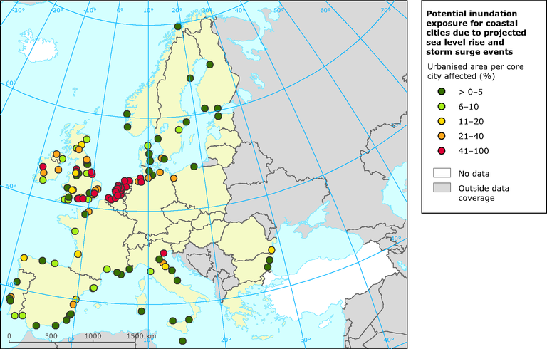
See all EU institutions and bodiesPotential inundation exposure for coastal cities due to projected sea level rise and storm surge events
Map (static)
The map shows the proportion of the city area (UMZ inside the core city) that would be affected by potential inundation caused by a sea level rise of 1m.

- Sea level rise (1m)
- Urban Audit
- Greece
- Poland
- Romania
- Portugal
- Spain
- United Kingdom
- Netherlands
- Belgium
- Germany
- France
- Czechia
- Italy
- Cyprus
- Estonia
- Latvia
- Lithuania
- Finland
- Hungary
- Bulgaria
- Malta
- Denmark
- Sweden
- Austria
- Luxembourg
- Ireland
- Slovakia
- Slovenia
Methodology
The data on maximum storm surge heights (100 year event) as generated by the DIVA project was used to determine actual medium inundation heights along coastal segments of each NUTS3 region. To account for the effects of climate change 1 meter of potential sea level rise until 2100 was calculated on top of these values. In order to determine potentially inundated areas the Hydro1k digital elevation model was utilised. By identifying those cells below the respective regional inundation threshold continuous areas have been delineated which can subsequently be considered to be potentially at risk of storm surge related inundation. However it has to be kept in mind that coastal defence systems have been neglected in this analysis since the employed database is missing this information.
Those information have been combined with the UMZ area inside the core cities (core city derived from Urban Audit / Urban Atlas) of all coastal cities for which the proportion of the area affected by 1m sea level rise is computed and represented by coloured dots in the map.
