All official European Union website addresses are in the europa.eu domain.
See all EU institutions and bodiesAn official website of the European Union | How do you know?
Environmental information systems
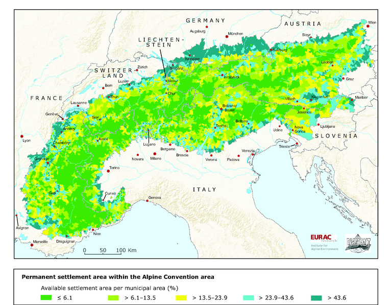
Permanent settlement area within the Alpine Convention area
Map (static)
Available settlement area at level of municipalities

Downloads
Data sources
Metadata
More info
Loading
- Data for the delination of municipalities: EuroGeographics (2005): Seamless Administrative Boundaries of Europe (SABE2004 v1.0).
- Based on Corine Landcover data 2000 the available settlement area is processed from the area for settlements from European Environment Agency (2005): Corine land cover 2000 (CLC2000) 100 m.
Data for intensively used agricultural areas are derived from national statistics as:
- AT Statistik Austria (1999): Agrarstrukturerhebung.
- CH Bundesamt für Statistik (1992-1997): Arealstatistik.
- DE Bayerisches Landesamt für Statistik und Datenverarbeitung (2001): Allgemeine Agrarstrukturerhebung.
- FR Agreste (2000): Recensement agricole; special analysis.
- IT ISTAT (2000): Censimento generale dell'agricoltura.
- LI Amt für Volkswirtschaft (2000): Landwirtschaftliche Betriebszählung.
- SI Statistični urad Republike Slovenije (2000): Popis kmetijstva.
