All official European Union website addresses are in the europa.eu domain.
See all EU institutions and bodiesAn official website of the European Union | How do you know?
Environmental information systems
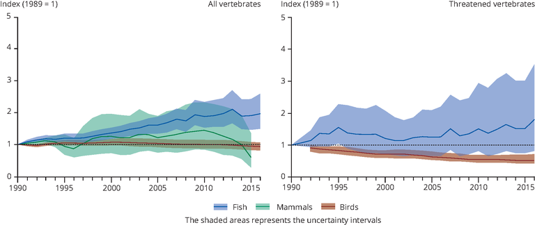
Living Planet Index calculated for main marine vertebrate groups
Chart (static)
The Living Planet Index (LPI) is used for a number of biodiversity indicators, based on geometric averaging.

Downloads
Data sources
Metadata
More info
Loading
- Living Planet Index (Dataset URL is not available)
- Adriatic Sea
- Aegean Sea
- Baltic Sea
- Bay of Biscay
- Black Sea
- Eastern Mediterranean
- English Channel
- Ionian Sea
- Kattegat
- Levantine Sea
- Mediterranean Sea
- North Sea
- Norwegian Sea
- Tyrrhenian Sea
- Western Mediterranean
1990-2016
Methodology
The Living Planet Index (LPI) is used for a number of biodiversity indicators, based on geometric averaging, using a GAM procedure (method explained and code provided here: https://github.com/Zoological-Society-of-London/rlpi).
Data was compiled from open access data sources by European Topic Centre (Inland, Coastal & Marine)
