All official European Union website addresses are in the europa.eu domain.
See all EU institutions and bodiesObserved change in global mean sea level
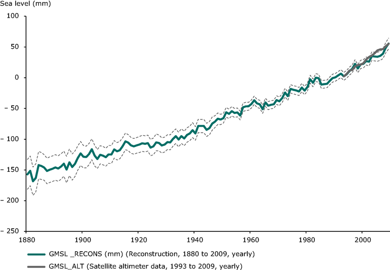
Chart (static)
The figure shows the global mean sea level from 1860 to 2009 as estimated from coastal and island sea-level data (1880 – 2009, blue) and from satellite altimeter data (1993 – 2009, grey).

- Arctic Ocean
- Atlantic Ocean
- Austria
- Baltic Sea
- Belgium
- Black Sea
- Bulgaria
- Cyprus
- Czechia
- Denmark
- Estonia
- Finland
- France
- Germany
- Greece
- Hungary
- Indian Ocean
- Ireland
- Italy
- Latvia
- Lithuania
- Luxembourg
- Malta
- Netherlands
- North Atlantic Ocean
- North Sea
- Pacific Ocean
- Poland
- Portugal
- Romania
- Slovakia
- Slovenia
- South Atlantic Ocean
- South Pacific Ocean
- Southern Ocean
- Spain
- Sweden
- United Kingdom
Additional information
Geographical coverage is global.
“While we attempted the reconstruction back to 1860, the results showed greater sensitivity to details of the method prior to the 1880s when the first southern hemisphere record is available (see below for further discussion). As a result, while we show the reconstruction back to 1860, we restricted the subsequent analysis (computation of trends, etc.) to after 1880.
“Prior to 1880 when there were less than 15 locations available and none in the southern hemisphere, there was considerably greater sensitivity to the parameter choice than for the rest of the record and hence we focus on results after 1880.”
