4. Discussion
4.1 Geographical coverage of monitoring stations
For 1997 information of 984 stations in EU Member States and of 92
stations in five other European countries has been received; for nearly all of them
geographical co-ordinates are available. For the interpretation of ozone data it is
essential to have an indication of the direct surroundings of the station as the ozone
concentration may be strongly influenced by local conditions. For example, the ozone
concentrations may be scavenged by locally emitted nitrogen oxides or by enhanced dry
deposition as might be the case under a forest canopy; see Annex II for a brief discussion
on ozone phenomenology. For nearly all stations information on immediate surroundings has
been made available.
As was observed in previous reports, not only the relative fractions of
street, urban and rural stations but also the station density varies strongly between the
reporting countries (De Leeuw et al., 1997; Beck et al., 1998), as Figure 3
shows. Here the station density as function of various indicators is given. The number of
stations per capita or per km2 land area varies strongly. The station density
relative to the Gross Domestic Product seems to be slightly more constant. When comparing
the number of stations with ozone precursor emissions (here the sum of NOx and twice the
VOC emissions is selected as indicator for ozone formation, see Sluyter, 1995), again a
wide spread is observed. More detailed indicators (number of urban stations (excluding
street stations) per urban dweller, number of rural stations per km2 show even
larger spread. It has to be stressed that a certain variation in densities is expected
over Europe as national conditions with respect to meteorology, topography/orography,
economic structure, physical planning etc. are different over Europe but the large
variations observed here suggest that basic principles in defining a monitoring strategy
differs strongly between the countries. In all cases the densities are normalised to a
unit density averaged over all 20 reporting countries.
Map 2 shows the location of background monitoring stations. Tentatively,
the area for which the measurements at these stations are assumed to be representative is
indicated with a circle using a radius of 100 km. This "radius of
representativeness" might be different for the various regions in Europe - it might
even depend on the wind direction - and should be based on more detailed analysis of the
ozone phenomenology at the stations. Although the identification of the background
stations is by far not complete and the radius of representativeness may differ from the
assumed 100 km, Map 2 suggests that the present set of stations covers 40 to 50% of the
area of the reporting countries. As is shown in Map 2 the geographical coverage of
background stations is rather adequate in north-west and Central Europe but in southern
regions gaps are noted. In Scandinavia the coverage by background stations seems to be
inadequate but the small gradients in ozone concentrations over this region suggest a
larger radius of representativiness than the assumed 100 km.
For comparing the monitoring results in the various countries it is
important that in the national or regional networks similar criteria are used to classify
the stations. Further work on harmonisation of station classification schemes is
undertaken by ETC/AQ in co-operation with DGXI (Larssen et al., 1998). A second
requirement for obtaining European wide comparable results is the harmonisation of air
quality measurements. This work is conducted on behalf of the Commission by the European
Reference Laboratory of Air Pollution (ERLAP) at the Joint Research Centre in Ispra.
Recently the results of a comparison of calibration procedures used by national
laboratories in EU and EFTA countries were published (De Saeger et al., 1997). 21
national laboratories made use of the facilities of ERLAP to check and compare their ozone
calibration methods with the ERLAP reference methods. During the inter-laboratory tests
the most commonly used technique for automatic measurements was based on UV absorption
photometry. With the exception of two analysers, the inter-comparisons showed that
measurements of various ozone concentrations were in good agreement (within 3%) with the
standard value. The good agreement between the calibration techniques and results obtained
by the participating laboratories shows the high level to which techniques for the
measurement of ambient ozone concentrations are harmonised throughout Europe. However,
periodical checks and maintenance of the analysers is essential to avoid interference with
other water vapour and other trace gases.
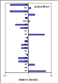
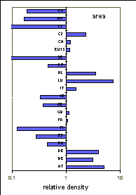


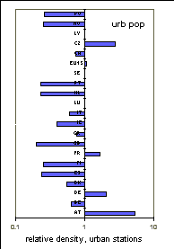
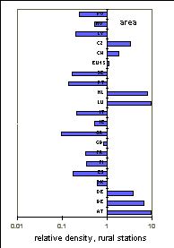
Figure 3. Station density (the averaged
density for all countries is normalised to unity) relative to population, land area, Gross
Domestic Product and precursor emissions. The second and third graph on the bottom line
show the density of urban station relative to the urban population and the number of rural
stations per km2, respectively. Averaged densities for the reporting countries
are respectively: 2.5 station per million inhabitants; 0.27 station per 1000 km2;
0.14 station per 109 US $ (1990 prices); 0.026 station per emitted kton; 1.26
urban station per million urban inhabitants; 0.08 rural station per 1000 km2.
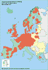
Map 2. Location of background ozone monitoring stations. Tentatively
the area for which the ozone measurements might be representative is indicated with a
circle with a radius of 100 km.
4.2 Annual statistics, 1997
The geographical distribution of 98-percentile values calculated on the
basis of hourly concentrations is presented in Map 3 for background stations and in Map 4
for urban, street and other stations.
Similar to the observations in previous years (de Leeuw et al.,
1997) the 98-percentiles at background stations show in general low values in the
Nordic countries, and an increase from Northwest to Central Europe. In particular for the
stations in Austria, the elevated location of the monitoring stations may play a role.
Similar patterns have been estimated from measurements made within the framework of EMEP
(Hjellbrekke, 1996). The relatively low values observed in the EMEP data over the Iberian
peninsula can not be confirmed (or rejected) with the present observations. Information
for Spain is not available; in Portugal there is only one rural station available for
comparison. Here a 98-percentile of 157 µg/m3 is observed. This is slightly
higher than the observed range of 116-149 µg/m3 (1995 data) at EMEP stations
in Spain and Portugal; the limited comparison and the difference in measuring period
precludes any conclusion.
For urban and 'other' stations (Map 4) no large scale concentration
gradient in 98-percentiles is recognised; high values are observed all over Europe. The
local conditions seems to be more important than European-wide smog episodes (at stations
downwind of the urban area relatively high ozone values might be observed whereas at
stations with NOx sources, such as traffic, in their immediate surrounding
relatively low ozone levels will be measured, see Annex II).
The 98-percentile values based on moving eight-hourly average
concentrations show a strong correlation with the hourly 98-percentile values: on the
average, 8-h percentiles are about 7 µg/m3 lower than the corresponding
1h value. The factual relation between the two statistics depends on the type of the
stations and has also a meteorological dependence. The geographical distribution of the
8-h percentile values is very similar to the distribution of the 1-h percentile values.
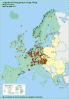
Map 3. 98 percentiles (based on hourly
concentrations; µg/m3) measured at background stations, period 1 January-
31 December 1997.
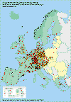
Map 4. 98 percentiles (based on hourly
concentrations; µg/m3) measured at urban, street and other stations, period
1 January- 31 December 1997.
4.3 Exceedances of thresholds in 1997
4.3.1. Exceedances of the threshold value for protection of
human health
The threshold value for protection of human health (110 µg/m3)
is based on eight-hourly values. According to the Ozone Directive, four eight-hourly
periods have to be considered: 0.00-8.00; 8.00-16.00, 16.00-24.00 and 12.00-20.00. Based
on the average diurnal profile of ozone (see Annex II) the highest eight-hourly values are
generally expected for the 12.00-20.00 period; only exceedances of the threshold values
for this period have been considered here.
No clear definition of the time reference (local time or universal time,
summer- or winter time) is given. This might lead to inconsistencies between the member
states. The differences between the maximum concentrations quoted for the 8-h
concentration between 12.00 and 20.00 (Table 3) and for the moving 8-h average
concentrations (Table 5) indicates that small errors might be introduced by the ambiguity
on time reference.
In 1997 exceedances of this threshold value have been observed in all
reporting countries. A maximum concentration exceeding twice the threshold value have been
observed in three Member States; on a moving 8-h average base, six countries report
concentrations above 220 µg/m3. The data submitted by Spain did not include
information on exceedances of this threshold. The frequency by which the threshold level
of 180 µg/m3 has been exceeded, suggest that, on the averaged, the level of
110 µg/m3 (8h) has been exceeded 20-30 times at a Spanish station.
| |
AT |
BE |
DE |
DK |
ES |
FI |
FR |
GB |
GR |
IE |
IT |
LU |
NL |
PT |
SE |
CH |
CZ |
LV |
NO |
PL |
#ex |
3360 |
577 |
9530 |
42 |
na |
69 |
3218 |
446 |
384 |
16 |
1353 |
131 |
567 |
228 |
57 |
761 |
1299 |
6 |
94 |
223 |
#st |
110 |
25 |
373 |
5 |
na |
10 |
147 |
69 |
12 |
6 |
40 |
5 |
39 |
10 |
6 |
13 |
46 |
1 |
14 |
14 |
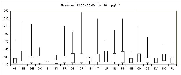
n.a = number of exceedances not availableFigure 4. Frequency distribution of ozone concentrations (eight-hourly values; period
12.00-20.00; 1 January - 31 December 1997) in excess of the 110 µg/m3 threshold
for hourly values. For each country the total number of observed exceedances is given in
row '#Ex', the number of stations is given in row '#St'. Frequency distributions are
presented as Box-Jenkins plots indicating the minimum, the 25-Percentile, the
75-percentile and the maximum value.
Figure 4 shows the frequency distribution of eight-hourly ozone
concentrations in excess of the threshold value using so-called Box-Jenkins plots. For
each country the Box-Jenkins plot indicates the minimum (here the minimum is of course 110
µg/m3), the maximum, the 25 percentile and the 75 percentile value of the
concentrations during exceedance. Although peaks of more than 200 µg/m3 are
observed in 7 out of 19 reporting Member States, Figure 4 shows that, in more than 75% of
all exceedance situations, the concentrations are below 165 µg/m3 (that is,
150% of the threshold value).
The geographical distribution of the number of days the threshold value
was exceeded is shown in Map 5 for background stations and in Map 6 for urban, street and
other stations. A comparison of Map 5 and Map 6 shows that exceedances are generally more
frequently observed at rural stations. This is also demonstrated more clearly in Figure 5
where for each station type (rural, urban and street stations) the average exceedance rate
is plotted. The average exceedance rate generally decreases in the order rural - urban -
street. Exceptions are found in Greece and Italy. It might be that this is caused by a
bias in the network configurations: in both countries there are much more urban than rural
stations, moreover, in Italy the rural stations are all located in the most northern part
on the country. Note that ŽŽotherŽŽ stations and stations for which the type has not been
specified are not presented in Figure 5.
Exceedances most frequently occur in the summer months (May - August).
In the winter months (January-March and September - December) exceedances have been
observed very occasionally.
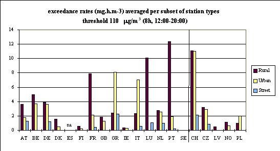
Figure 5. The exceedance rate of the
threshold value for protection of human health (110 µg/m3 for eight-hourly
values (in mg.h/m3), period 1 January - 31 December 1997) averaged over all
reporting rural, urban, and street stations. No information is available for Spain.
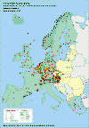
Map 5. Number of exceedances of the
threshold value for protection of human health (110 µg/m3 for eight hourly
values) observed at background stations; 1 January - 31 December 1997; eight-hourly
average values for the period 12.00-20.00.
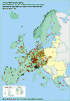
Map 6. Number of exceedances of the threshold value for protection of
human health (110 µg/m3 for eight-hourly values) observed at urban, street and
other stations; 1 January - 31 December 1997; eight-hourly average values for the period
12.00-20.00.
4.3.2. Exceedances of the threshold values for information and
warning of the population.
The threshold value for warning of the population (360 µg/m3,
hourly value) has been exceeded in 1997 on 18 June, 13.00 at one station (Lykovrissi) in
Athens, Greece This day was the start of an ozone episode in Athens. The station
Lykovrissi reported exceedances of the human health related threshold value of 110 µg/m3
for 8-hourly averaged during the period 18-24 June. During the whole month of June,
concentrations were high in Athens: on 17 days at least one (out of seven) stations
reported an hourly value exceeding 180 µg/m3. On 22 June all seven station
reported an exceedance with an maximum of 229 µg/m3. See for a more extensive
description of this episode de Leeuw et al. (1997).
The geographical distribution of the number of exceedances of the
threshold value for information of the public (180 µg/m3, hourly value) is
presented in Map 7 for background stations and in Map 8 for urban, street and other
stations. Exceedances are reported by 15 countries (12 Member States). In Ireland and in
the most northern countries the 180 µg/m3 level has not been reached.
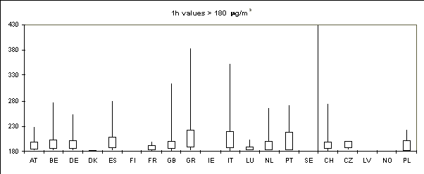
Figure 6 shows the frequency distribution of concentrations in excess of
the threshold value. Although incidentally the threshold value may be exceeded by more
than a factor of two, in almost all of the cases the exceedances are less extreme: Figure
6 shows that in nearly all Member States on 75% of the days on which the threshold value
was exceeded, the level of 240 µg/m3 (that is 33% above the threshold value)
has not been reached.
| |
AT |
BE |
DE |
DK |
ES |
FI |
FR |
GB |
GR |
IE |
IT |
LU |
NL |
PT |
SE |
CH |
CZ |
LV |
NO |
PL |
#ex |
15 |
81 |
534 |
1 |
151 |
0 |
181 |
48 |
111 |
0 |
1128 |
5 |
47 |
34 |
0 |
48 |
8 |
0 |
0 |
7 |
#st |
111 |
25 |
373 |
5 |
36 |
11 |
148 |
71 |
11 |
6 |
92 |
5 |
38 |
11 |
6 |
13 |
48 |
1 |
14 |
14 |
Figure 6. Frequency distribution of ozone concentrations (hourly values; 1 January
- 31 December 1997) in excess of the 180 µg/m3 threshold for hourly values. For each
country the total number of observed exceedances is given in row '#Ex', the number of
stations is given in row '#St'. Frequency distributions are presented as Box-Jenkins plots
indicating the minimum, the 25-Percentile, the 75-percentile and the maximum value.
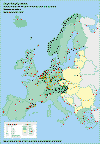
Map 7. Number of exceedances of the threshold value for information of the
population (180 µg/m3 for hourly values) observed at background stations; 1
January - 31 December 1997.
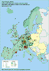
Map 8. Number of exceedances of the threshold value for information of the
population (180 µg/m3 for hourly values) observed at urban, street and other
stations; 1 January - 31 December 1997.
4.3.3. Exceedances of the daily threshold value for
protection of vegetation
As Table 4 shows, exceedances of the daily threshold of 65 µg/m3
have been frequently observed in all reporting countries. All countries have stations
where the threshold has been exceeded on more than 100 days in 1997 with the exception of
Latvia and the Netherlands. The geographical distribution of the number of exceedances of
the daily threshold is presented in Map 9 for the background stations. In Map 9 an attempt
has been made to quantify the area where exceedances are observed. For the background
stations a representative radius of 100 km is assumed, see also Map 2. When the
"representative areas" of two or more stations overlap, the number of
exceedances in this location is estimated by a distance-weighted interpolation. At all
rural stations exceedances of the 65 µg/m3 level have been reported; the
lowest number (5 days of exceedance) has been reported for the German station Ffm.
Greisheim located near Frankfurt am Main. Exceedances on more than 150 days are reported
both by northern and southern Member States.
For exceedances of a daily average concentration the differences between
rural and urban stations are more pronounced than is the case for hourly concentrations.
In urban areas the low concentrations during the night (caused by interaction with NOx
emissions) reduce the daily average concentrations; in rural areas the decrease in ozone
concentrations during the night is generally less strong. In NW Europe, however, the high
NOx emission density might cause also some quenching of ozone at rural sites
which explains the relative low number of exceedances in this region compared both to
North and South Europe.
Figure 7 shows the frequency distribution of daily values in excess of
65 µg/m3. Although high values of more than 200 µg/m3 have been
observed, in nearly all countries for 75% of the exceedances the daily average
concentration falls between 65 and 98 µg/m3 (that is 150% of the threshold
value). The extremely high values reported for Italy are most likely in error; there are
clear indication that at several station the maximum observed 1h concentration has been
reported as daily averaged. The exceedances are most frequently observed during the
growing season (May-July): more than 45% of the exceedances were reported in this
three-month period. About 18% of the exceedances occurred during the winter months
(January to March and October to December).
In Figure 8 the exceedance rates, averaged per subset of stations types,
are given for each country. This figure clearly shows that especially at rural stations
this threshold value is frequently and largely exceeded. High exceedance rates are
observed both in northern and southern countries.

| |
AT |
BE |
DE |
DK |
ES |
FI |
FR |
GB |
GR |
IE |
IT |
LU |
NL |
PT |
SE |
CH |
CZ |
LV |
NO |
PL |
#ex |
13224 |
1261 |
23737 |
392 |
na |
1407 |
9305 |
2209 |
840 |
440 |
3466 |
352 |
1198 |
475 |
997 |
1759 |
5356 |
55 |
2057 |
1265 |
#st |
111 |
25 |
371 |
5 |
na |
11 |
144 |
67 |
13 |
6 |
51 |
5 |
38 |
9 |
6 |
13 |
48 |
1 |
14 |
16 |
Figure 7. Frequency distribution of ozone concentrations
(24h values; 1 January - 31 December 1996) in excess of the 65 µg/m3 threshold
for daily values. For each country the total number of observed exceedances is given in
row '#Ex', the number of stations is given in row '#St'. Frequency distributions are
presented as Box-Jenkins plots indicating the minimum, the 25-Percentile, the
75-percentile and the maximum value.
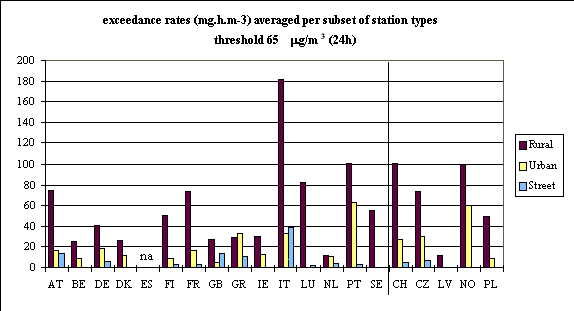
Figure 8. The exceedance rate of the threshold value for
protection of vegetation of 65 µg/m3 for daily values (in mg.h/m3),
period 1 January - 31 December 1997) averaged over all reporting rural, urban, and street
stations. No information is available for Spain.
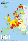
Map 9. Number of exceedances of the threshold value for vegetation (65 µg/m3
for daily values) observed at background stations; 1 January - 31 December 1997. Data is
interpolated using inverse distance weighting and a cut-off distance of 100 km.
4.3.4. Exceedance of the hourly threshold value for protection
of vegetation
Exceedances of the hourly threshold values for protection of vegetation
(200 µg/m3) have been reported by 10 Member States; no exceedances have been
observed in Denmark, Finland, Ireland and Sweden, see Table 4. The geographical
distribution of the number of days on which this hourly threshold value has been exceeded
is presented in Map 10 for background stations. The map shows that roughly above 550
N this threshold value has not been exceeded. The highest number of exceedances at a rural
station (13 times) is observed at the German station Schwarzwald-Süd, see Map 10.
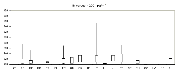
The frequency distributions of exceedances of the hourly threshold are
presented in Figure 9. For about 75% of the exceedances the ozone levels fall between 200
and 275 µg/m3.
| |
AT |
BE |
DE |
DK |
ES |
FI |
FR |
GB |
GR |
IE |
IT |
LU |
NL |
PT |
SE |
CH |
CZ |
LV |
NO |
PL |
#ex |
3 |
25 |
143 |
0 |
na |
0 |
110 |
12 |
61 |
0 |
531 |
1 |
10 |
13 |
0 |
11 |
1 |
0 |
0 |
2 |
#st |
111 |
25 |
373 |
5 |
na |
11 |
151 |
71 |
10 |
6 |
82 |
5 |
38 |
11 |
6 |
13 |
48 |
1 |
14 |
14 |
Figure 9. Frequency distribution of ozone concentrations
(hourly values; 1 January - 31 December 1997) in excess of the 200 µg/m3 threshold
for hourly values. For each country the total number of observed exceedances is given in
row '#Ex', the number of stations is given in row '#St'. Frequency distributions are
presented as Box-Jenkins plots indicating the minimum, the 25-Percentile, the
75-percentile and the maximum value.
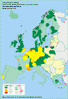
Map 10. Number of exceedances of the threshold value for vegetation (200 µg/m3
for hourly values) observed at background stations; 1 January - 31 December 1997. Data is
interpolated using inverse distance weighting and a cut-off distance of 100 km.
4.5 Preliminary review of exceedances of the revised
guidelines of WHO
As mentioned in Chapter 1 the World Health Organization in Europe came
forward with a revision of its guidelines for ozone (WHO, 1996a,b), see Table 6. According
to the 5th Environment Action Programme these guidelines shall serve as a basis
for setting air quality standards in the Community. While these values are also relevant
in the context of preparing the new daughter directive for ozone an attempt has been made
to evaluate the ozone data submitted under the framework of the current directive against
these guideline levels. This can only be a very preliminary evaluation as the available
information deviates from the requirements on averaging time and period given in Table 6.
Table 6. An overview
of ozone guideline levels of WHO.
| Description |
level |
Time period |
Constraints |
| human health |
120 µg/m³ |
Floating 8h mean |
|
| for vegetation: |
|
|
|
| Crops and semi-natural vegetation |
AOT40* = 3 ppmh |
3 months
(May-July) |
|
| Forests |
AOT40 = 10 ppmh |
6 months
(April-September) |
|
| Crops (visible injury) |
AOT40= 0.2 ppmh
AOT40= 0.5 ppmh |
5 days
5 days |
Humid air conditions
Dry air conditions |
* calculated from 1h mean values during daylight hours; 1ppmh = 1000 mg.m-3.h
Referring to the guideline for human health, the exceedances reported for the 8h period
between 12.00 and 20.00 has been used to evaluate exceedances of the threshold value of
120 µg/m3 for moving 8-h values. In 1997, at one out of every five stations
the 8h-averaged concentration between 12.00 and 20.00 is in excess of a level of 120 µg/m3
on more than 20 days. As ozone concentrations generally reach their maximum in the
late afternoon, the mean over the fixed period 12.00-20.00 is expected to be a good
approximation of the highest daily 8-h values calculated from a moving averaged. Figure 10
shows a European wide exceedance of this threshold value. However, evaluation of hourly
data has shown that when comparing the number of exceedance days calculated from moving
8-hourly means with such based on the fixed 12-20 h period, the latter is about 15% lower,
in urban areas even 25% (Martin Lutz, private communication). Figure 10 might therefore
give an underestimation of the exceedances of the WHO guideline value.
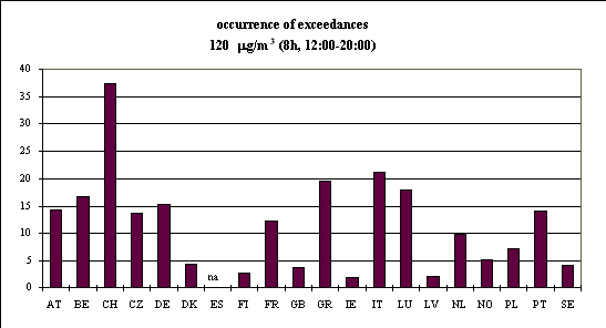
Figure 10. The occurrence of exceedances of the WHO
guideline for protection of human health (120 µg/m3 for moving 8-hourly
values; calculations are, however, based ozone levels reported for the fixed time period
12.00-20.00h, see text), averaged over all stations; period 1 January - 31 December 1997.
Evaluation on the AOT40 values for vegetation is not possible using the available
information. A crude estimate might be based on the information on exceedance of a daily
concentration of 65 µg/m3. The exceedance rate (see Eq 2) of a
threshold of 80 µg/m3 (ER40) and the AOT40 values differ, however, on the time
window for integration: the AOT40 is based on hourly values during the 'daylight'-period
(8.00-20.00 CET) whereas the ER40 is based on 24h per day. A longer integration time might
lead to higher values. On the other hand, days with a daily average below 80 µg/m3
do not contribute to the ER40 but may contribute to the AOT40 when hourly averages peak
above 80 µg/m3. Due to these differences the exceedance rate may either over-
or underestimates the AOT40. A preliminary analysis using hourly data for a limited number
of stations in Latvia, the Netherlands, and the United Kingdom showed that the ER40 is
lower than the corresponding AOT40; in some cases AOT40 is even a factor 3-8 higher than
the ER40.
An exceedance rate of 6000 mg.m-3.h has been exceeded in 1997 on 26% of all
reporting stations; limiting the analysis only to the rural stations, this percentage
increases to 41%. In view of the discussion above this will give a severe underestimation
of the stations where the WHO critical level for protection of crops and semi-natural
vegetation (AOT40 = 6000 mg.m-3.h) is exceeded. Both observations as well as
model calculations made within EMEP (EMEP MSC-W, 1998) show that south of 55-57o N
an AOT40 of 6000 mg.m-3.h is exceeded in more than 90% of the area.
It must be concluded that the information currently collected under the Ozone Directive
is not adequate to assess exceedances of the revised WHO-guidelines for ozone.
4.6. Data reported for 1994-1997
Trends in ozone concentrations are expected to result from trends in
precursor emissions in Europe and from the increasing trend in hemispheric background
concentrations (Borrell and van den Hout, 1995). The magnitude and even the sign of a
possible trend might differ from location to location. In a study of trends in
concentrations of ozone and related species in the Netherlands and nearby countries Roemer
(1996) concluded that the ground level oxidant (sum of ozone and NO2)
concentrations have decreased significantly in the Netherlands from 1981 to 1994 with an
average decrease of about 1% per year. For Germany a slightly downward (in the northern
part) or slightly upward (in the southern part) trend was noted but probably none of these
trends is significant at the 95% confidence interval (Roemer, 1996).
From an analysis of ozone concentrations in "unpolluted" air
masses arriving over the North Atlantic region at the UK station Mace Head. it appeared
that over the 1990-1996 period there is an upward trend of 0.092 ppb per year (or 0.2% per
year) in background ozone concentrations (PORG, 1997). Model calculations on a global
scale support the findings of a ongoing change in chemical composition of tropospheric
background air. Today daily mean concentrations of ozone are three to four times higher
than in the pre-industrial era as a result of the tremendous growth in NOx
emissions from industry and the transport sector.
The year to year variation in 50-percentile values are relatively small
(2 -7 µg/m3 on a P50-value of about 30 to 60 µg/m3) when compared
to the variations in the 98-percentile values (a variation of 11-18 µg/m3 for
P98-values ranging from 76-145 µg/m3). Peak values of ozone are strongly
correlated with temperature mainly because the conditions leading to high temperatures
(e.g. strong solar radiation, low wind speeds, continental flows) also trigger
photochemical formation. Meteorological fluctuations may cause variations in peak ozone
levels that are much larger than the variations due to changes in precursor emissions. A
yearly fluctuation of about 15% in 98-percentile value is not exceptional.
The time series reported in the framework of the Ozone Directive, now
covering a period of four year (1994-1997), are still too short or too variable in terms
of station configuration to give conclusive answers on an ozone trend in the whole of the
EU. Figure 11 shows the number of occurrence of exceedance (that is, the number of
exceedances averaged per station) for the 110 µg/m3 and the 65 µg/m3
level over the four-year period. Judging the exceedances of the 110 µg/m3
threshold, 1997 is a year with generally a low number of exceedances and a decreasing
trend is observed in some countries (e.g. AT, DE) but not in all (see, for example IT). A
different picture is found for exceedances of the daily threshold of 65 µg/m3.
Here, 1997 is not a year with an outspoken low number of exceedances; for a number of
countries (AT, BE, FR, IT, PT, SE) 1997 is even the year with the highest numbers. Data
for DK, GB, and GR suggest on the other hand, a decreasing trend.
For various Member States data reports are available for years previous
to 1994. Longest time series are available for Belgium, Luxembourg, the Netherlands, and
United Kingdom. At the level of the individual stations in these countries, a possible
trend in ozone levels has been examined using the non-parametric Mann-Kendall test
(Gilbert, 1987). Only those stations for which at least data for 5 years are available
have been included in the tests. The results for trends in 50- and 98-percentile values
are summarised in Table 6. For most on the stations no significant trend in 50-percentile
values is observed. For the stations with a significant trend, the results are mixed. An
upward trend of 1-3 µg/m3 per year is seen at a few stations in Belgium and
Luxembourg. Trends in the United Kingdom may either be positive or negative. The same is
true for the Netherlands, although here the number of stations with a downward trend
outweighs the number of stations with a positive trend. In the analysis of the
98-percentiles also no clear picture for a country of region evolved. Only for the
Netherlands the majority of stations shows a downward trend but here artefacts caused by
the introduction of a new ozone monitor during the winter of 1990/1991 might not be
excluded (RIVM, personal communication).
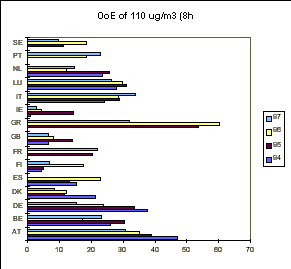
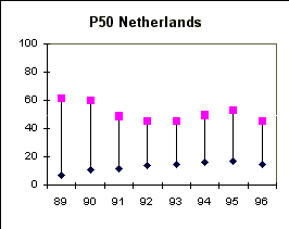
Figure 11. Occurrence of exceedances of
threshold values of 110 (8h) and 65 (24h) µg/m3 in EU Member States during the
period 1994-1997.
Table 6. Trend estimates for 50- and
98-percentile values for individual stations in Belgium, United Kingdom, Luxembourg and
the Netherlands; period 1989-1997.
| member state |
number of stations (1) |
slope range (µg/m3 per year)
(2) |
| 50-percentile |
|
|
| BE |
7(3,0) |
1.6 « 3.3 (0.0 « 3.3) |
| GB |
24 (2,2) |
-1.0 « 1.4 (-1.0 « 1.4) |
| LU |
5 (2,0) |
0.9 « 2.6(-1.8 « 2.6) |
| NL |
32(3,10) |
-1.6 « 0.9 (-1.6 «1.0) |
| 98 percentile |
|
|
| BE |
7 (1,0) |
1.5 (-2.5 « 8.3) |
| GB |
24 (0,2) |
-6.7 « -6.0 (-6.7 « 6.0) |
| LU |
5 (1,0) |
1.8 (-0.3 « 3.0) |
| NL |
32 (0,20) |
-6.3 « -2.6 (-6.3 « 3.0) |
(1) in parentheses the number of stations with a significant upward,
respectively downward trend (at an a = 0.10 significant level) is given;
(2) range in estimated annual trends for stations with significant trend;
results for all stations including those where no significant trend has been observed are
given in parentheses.
Acknowledgment
The authors are indebted to Jaroslav Fiala and Hana
Livorova at the PHARE Topic Link on Air Quality and Jana Ostatnicka at the Czech
Hydrometeorological Institute for the cartographic contributions and further GIS support .


Document Actions
Share with others