All official European Union website addresses are in the europa.eu domain.
See all EU institutions and bodiesAn official website of the European Union | How do you know?
Environmental information systems
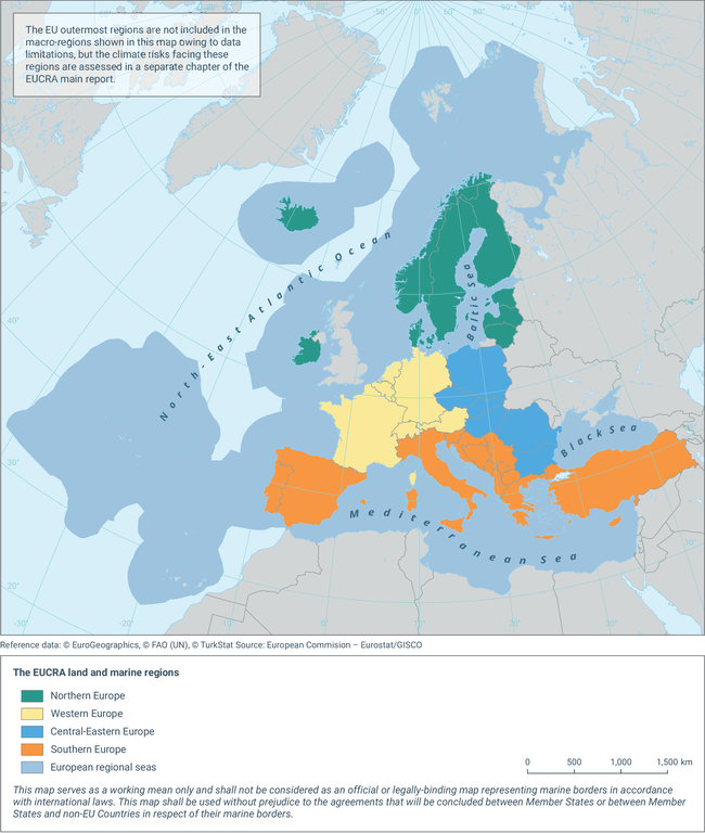
The EUCRA land and marine regions
Map (static)
Spatially aggregated regions for four sub-continental land and four marine regions. Regionalisation for land regions based on UN Geoscheme for Europe.

Downloads
Data sources
Metadata
More info
Loading
- EUCRA land regions (direct link to dataset not available)
- Regional seas around Europe - version 2, Oct. 2022
- Albania
- Austria
- Baltic Sea
- Belgium
- Black Sea
- Bosnia and Herzegovina
- Bulgaria
- Croatia
- Cyprus
- Czechia
- Denmark
- Estonia
- Finland
- France
- Germany
- Greece
- Hungary
- Iceland
- Ireland
- Italy
- Kosovo (UNSCR 1244/99)
- Latvia
- Liechtenstein
- Lithuania
- Luxembourg
- Malta
- Mediterranean Sea
- Montenegro
- Netherlands
- North Macedonia
- North-East Atlantic Ocean
- Norway
- Poland
- Portugal
- Romania
- Serbia
- Slovakia
- Slovenia
- Spain
- Sweden
- Switzerland
- Türkiye
2023
Additional information
The following adaptations have been made to the UN Geoscheme to ensure that all European Economic Area (EEA) member and cooperating countries (EEA-38) are covered:
• Omitting all countries that are not part of EEA-38
• Including Cyprus and Türkiye in ‘Southern Europe’ (rather than ‘Western Asia’)
• Changing the name of ‘Eastern Europe’ to ‘Central-Eastern Europe’ (to avoid confusion with the IPCC AR6 WGII region ‘Eastern Europe’, with which it does not overlap)
