All official European Union website addresses are in the europa.eu domain.
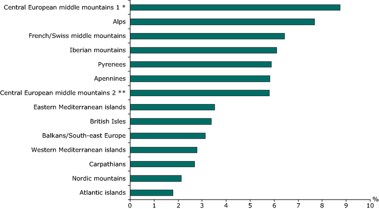
See all EU institutions and bodiesProportion of mountain massifs affected by TEN-T infrastructure
Chart (static)
The graph describes the percentage of each massifs affected by infrastructure network (Roads, railways and inland waterways of versions 1996, 2001 and 2003).

- Albania
- Austria
- Belgium
- Bulgaria
- Croatia
- Cyprus
- Czechia
- Denmark
- Estonia
- Finland
- France
- Germany
- Greece
- Hungary
- Iceland
- Ireland
- Italy
- Latvia
- Liechtenstein
- Lithuania
- Luxembourg
- Netherlands
- Norway
- Poland
- Portugal
- Romania
- Slovakia
- Slovenia
- Spain
- Sweden
- Switzerland
Methodology
The source data is the GISCO Infrastructure theme as maintained by DG TREN. The original TEN network coverages were created on top of the GISCO Infastructure datasets. Where possible, the network has been converted to use the EUROGLOBALMAP derived TransportationEdge geometry.
The mountain massives were created from the EEA-mountain mask (based on a 1*1 km DEM and the rules according to the DG Regio/Nordregio/UNEP-WCMC project). The main geografic entitites of mountain massives were delineated. In total 15 massives were differentiated. The massives follow rather socio-economic parameters than detailed biogeografic ones. The purpose of the delination was to reveal comparable massives for european wide socio-economic spatial analysis. The underlying mountain mask was generated from the mountain mask GRID using the "simplify polygon" option. Therefore the borders do not match the 1*1km GRID. The delination of mountain massives were made manually using mainly NUTS 3 units to differentiate between the massives. In case of logical borders within a NUTS 3 unit, the massives were splitted along these logical borders.
