All official European Union website addresses are in the europa.eu domain.
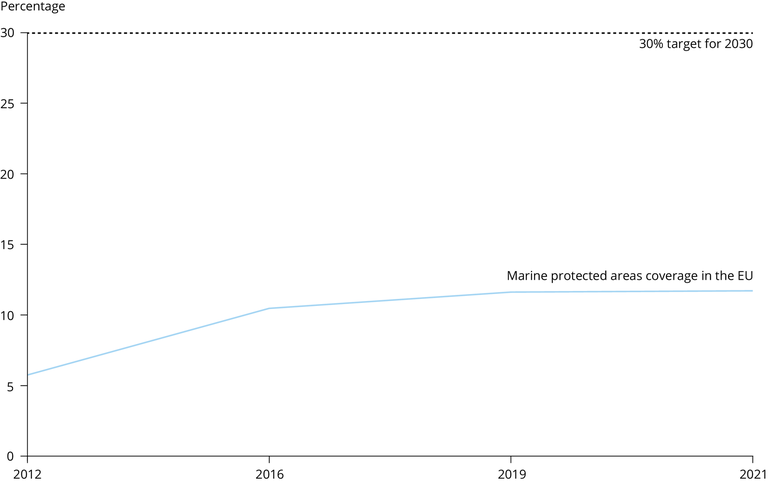
See all EU institutions and bodiesMarine protected area coverage in the EU, 2012-2021
Chart (static)
The figure shows marine protected areas coverage in the EU in 2012-2021.

- HELCOM MPAs
- OSPAR Marine Protected Areas Network
- EEA marine assessment areas - version 3.0, Oct. 2022
- Austria
- Belgium
- Bulgaria
- Croatia
- Cyprus
- Czechia
- Denmark
- Estonia
- Finland
- France
- Germany
- Greece
- Hungary
- Ireland
- Italy
- Latvia
- Lithuania
- Luxembourg
- Malta
- Netherlands
- Poland
- Portugal
- Romania
- Slovakia
- Slovenia
- Spain
- Sweden
- United Kingdom
Methodology
The end2012 (meaning the data reported in 2012), end2016, end2019 MPA data were taken from the respective EEA and ETC/ICM reports (Agnesi et al. 2020 and 2017, EEA 2015). These were combined with new data produced in 2022 based on the latest available data. An overview of the datasets used to support the analysis is provided in the Data and sources below.
The methodology and the procedure used for selecting marine Natura 2000 and CDDA sites from the tabular and spatial data are outlined in detail in Section 2.6 of the EEA (2015) report and in Agnesi et al. (2017).
The spatial statistics were carried out in ArcGIS. The calculations were automated by a series of procedures developed in Python language. The conceptual basis of the analysis procedures can be found in Agnesi et al. (2017) and are therefore only briefly described here. The procedures included creation of a feature class, for every protected areas network, containing Natura 2000 and CDDA MPAs for every Member State. The dissolve operation was used to estimate the surface coverage so as to exclude any overlap between sites. After having obtained the surface area estimate per network, the overall surface of the combined networks was calculated through the union of the dissolved features of the different networks. An ad hoc routine was written to assign the values of the distinct N2K and CDDA coverage and the overlapping portion of these networks. The surface area coverage was extracted from each feature class and the percentage cover was obtained by relating the surface of protected area against that of the marine waters of each MS on the overall.
Additional information
- Data up to 2019 show marine protected area coverage for the EU-27 and the UK (excluding landlocked countries); after 2019, data show coverage for only the EU-27 (excluding landlocked countries).
- Geographical coverage is "EU-27+UK" but excluding landlocked countries since it's an indicator for marine protected areas coverage. Therefore, the list of EU countries covered by this indicator includes: Belgium, Bulgaria, Croatia, Cyprus, Denmark, Estonia, Finland, France, Germany, Greece, Ireland, Italy, Latvia, Lithuania, Malta, Netherlands, Poland, Portugal, Romania, Slovenia, Spain, Sweden, United Kingdom.
