All official European Union website addresses are in the europa.eu domain.
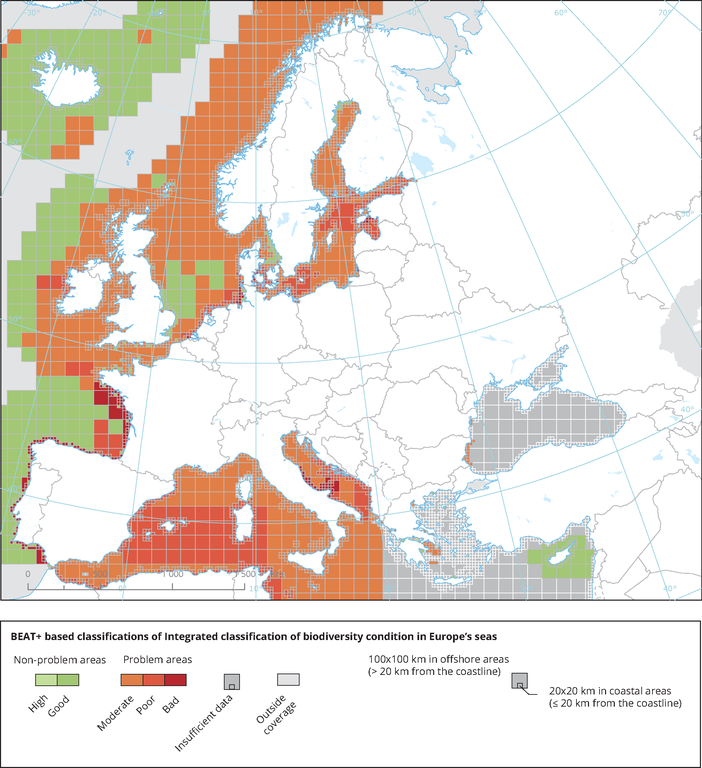
See all EU institutions and bodiesIntegrated classification of biodiversity condition in Europe’s seas
Map (static)

Based on BEAT+ classification of biodiversity in Europe’s seas’. For further details on classification methods, please refer to (EEA, 2019a) and (ETC/ICM, 2019a).
- Adriatic Sea
- Aegean Sea
- Baltic Sea
- Bay of Biscay
- Black Sea
- Celtic Sea
- Eastern Mediterranean
- English Channel
- Ionian Sea
- Levantine Sea
- Mediterranean Sea
- North Atlantic Ocean
- North Sea
- Norwegian Sea
- Tyrrhenian Sea
- Western Mediterranean
Units
Dimensionless status class:
High and Good: are recognised as ‘non-problem areas’
Moderate, Poor and Bad are recognised as ‘problem areas’
Additional information
BEAT+ has been designed to provide an assessment of the spatial variability of a range of biodiversity components by combining existing biodiversity indicators
Marine messages II has developed, tested and applied a new multi‑metric indicator‑based assessment tool named 'European Marine Ecosystem Condition (Health) Tool' (MESH+). The MESH+ tool builds on the EEA assessment tools developed and applied in the context of assessing the degree of contamination (CHASE+), eutrophication (HEAT+) and biodiversity (BEAT+) in Europe's seas (EEA, 2018a, 2019c; Vaughan et al., 2019). MESH+ makes use of the same data sets and threshold values used in these assessments but recombines these in a new framework that addresses 'ecosystem condition'.
