All official European Union website addresses are in the europa.eu domain.
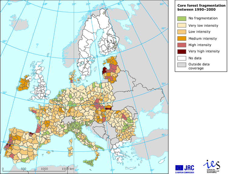
See all EU institutions and bodiesCore forest fragmentation between 1990 and 2000
Map (static)
Data from Corine Land Cover (CLC) for years 1990 and 2000, hence with same geographical coverage and forest definition as CLC; mathematical morphology based software GUIDOS (Soille and Vogt, 2009) and GIS analysis; results aggregated at provincial units (NUTS level 2/3).

- Greece
- Poland
- Romania
- Portugal
- Spain
- United Kingdom
- Netherlands
- Belgium
- Germany
- France
- Czechia
- Italy
- Cyprus
- Estonia
- Latvia
- Lithuania
- Finland
- Hungary
- Bulgaria
- Malta
- Denmark
- Sweden
- Austria
- Luxembourg
- Ireland
- Slovakia
- Slovenia
Methodology
Results aggregated at provincial units, NUTS level 2 or 3.
Ranges for levels of increase are: very high for above 100 % increase with respect to the total number of core forest patches in 1990; high for the range 50–100%; medium for the range 25–50 %; low for the range 5–25%; and very low for below 5%.
References:
Riitters, K. H.; Wickham, J. D. and Wade, T. G., 2009. 'An indicator of forest dynamics using a shifting landscape mosaic'. Ecological Indicators 9:107–117.
Soille, P. and Vogt, P. 2009. Morphological segmentation of binary patterns. Patterns Recognition Letters. doi:10.1016/j.patrec.2008.10.015.
Saura, S. and Torné, J., 2009. 'Conefor Sensinode 2.2: A software package for quantifying the importance of habitat patches for landscape connectivity'. Environmental Modelling & Software 2009 24:135–139.
Saura S.; Mouton, C. and Estreguil, C., 2009. European-wide maps of change in forest connectivity in 1990–2000. Joint Research Centre of the European Commission, Internal publication Pubsy reference 51278
1) JRC; Estreguil and Mouton, 2009; European Forest Data Centre. (JRC EFDAC Map viewer at http://efdac.jrc.ec.europa.eu/)
The data derive from Corine land cover (CLC) for the years 1990 and 2000 and, hence, have the same geographical coverage and forest definition as CLC; core forest from mathematical morphology-based software GUIDOS from Soille and Vogt, 2009, and GIS analysis. Results aggregated at provincial units, NUTS level 2 or 3. Ranges for levels of increase are: very high for above 100 % increase with respect to the total number of vore forest patches in 1990; high for 50-100 %; medium for 25-50 %; lov for 5-25 %; and very low for below 5 %.
2) Corine land cover (CLC1990) 100 m - version 9/2007
3) Corine land cover 2000 (CLC2000) 100 m - version 9/2007
4) NUTS (Nomenclature of Territorial Units) version 9 2007. http://ec.europa.eu/eurostat/ramon/nuts/home_regions_en.html
