All official European Union website addresses are in the europa.eu domain.
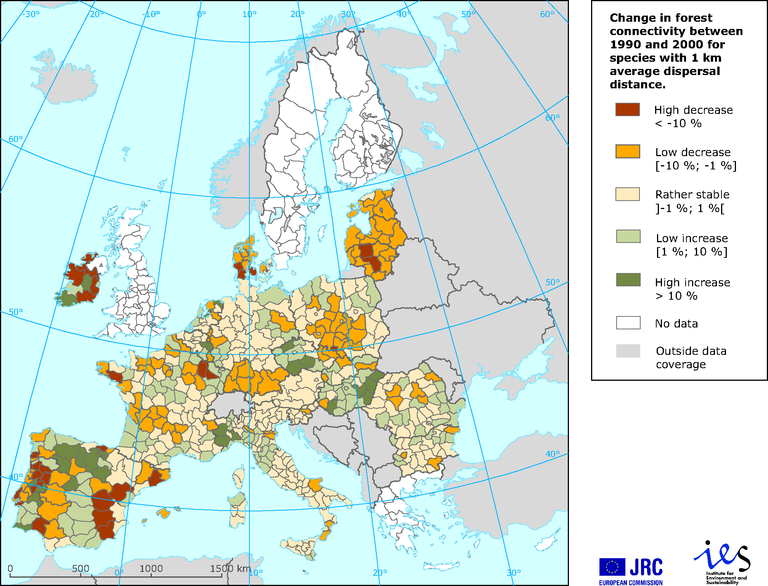
See all EU institutions and bodiesChange in forest connectivity between 1990 and 2000
Map (static)
How to read the map: in eastern Spain, there was a high decrease in forest connectivity between 1990 and 2000 for forestdwelling species with 1 km average dispersal distance

- Image 2000 & Corine Land Cover 2000 (dataset URL not directly available)
- Data on forests in Europe
- Austria
- Belgium
- Bulgaria
- Cyprus
- Czechia
- Denmark
- Estonia
- Finland
- France
- Germany
- Greece
- Hungary
- Ireland
- Italy
- Latvia
- Lithuania
- Luxembourg
- Malta
- Netherlands
- Poland
- Portugal
- Romania
- Slovakia
- Slovenia
- Spain
- Sweden
- United Kingdom
Methodology
The data derive from Corine Land Cover (CLC) for the years 1990 and 2000 and hence have the same geographical coverage and forest definition as CLC; connectivity derived from Conefor Sensinode software of Saura and Torné 2009, and GIS analysis. Range levels are expressed as % of increase (or decrease) of equivalent connected area in 1990. GIS analysis and results aggregated at provincial units, NUTS level 2 or 3.
Riitters, K. H.; Wickham, J. D. and Wade, T. G., 2009. 'An indicator of forest dynamics using a shifting landscape mosaic'. Ecological Indicators 9:107–117.
Soille, P. and Vogt, P. 2009. Morphological segmentation of binary patterns. Patterns Recognition Letters. doi:10.1016/j.patrec.2008.10.015.
Saura, S. and Torné, J., 2009. 'Conefor Sensinode 2.2: A software package for quantifying the importance of habitat patches for landscape connectivity'. Environmental Modelling & Software 2009 24:135–139.
Saura S.; Mouton, C. and Estreguil, C., 2009. European-wide maps of change in forest connectivity in 1990–2000. Joint Research Centre of the European Commission, Internal publication Pubsy reference 51278.
